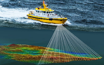
The overview of physical characteristics existing underwater is called a hydrographic survey, often known as a bathymetric survey. The study of evaluating all submerged factors that affect all maritime activities, such as digging, marine developments, offshore drilling, and so on. To ascertain the properties of the shoreline and the ocean floor, hydrographic surveys are utilised.
To create nautical diagrams that contain accessible depths, piers, enhanced channels, the directions to navigate a port facility, and breakwaters, hydrographic surveying data must be obtained.
These surveys also contribute to the basic information gathering related to port office development and enhancements, such as pier development. This makes it easier to determine the capacity limit due to slit and other issues.
Driven by innovation and technical excellence, Compass Engineering continues to grow as a trusted name in the surveying industry — transforming ideas into reality with our vision, “Concept to Creation.”
Copyright ©2026 All rights reserved | Digital Marketing
WhatsApp us for more info.